So sitting here having a few too many, I came up with a thought. Whenever you look at a map of the U.S, you see the roads and mountains from above. If you are traveling by car, it throws you for a loop when you hit a 3000 foot mountain in between. I am curious if anyone has come out with a map of the U.S that is ground level. The reason I ask is that I have always been curious of how Denver, the "Mile High" State would look from the side. Do the roads just ascend for a mile and Denver looks like one huge flat-topped mountain and then descend back to the next State? It would be cool to have a map that actually showed the height of the State in relation to the rest of the U.S and the rest of the geography. Just a drunk thought.....but a serious one
IP: Logged
11:45 PM
PFF
System Bot
Wichita Member
Posts: 20709 From: Wichita, Kansas Registered: Jun 2002
You really wouldn't see much. Using your example, Colorado is about 440 miles east to west along I-70, so if your map was a yard wide, Denver would be less than .04" above where you entered the state in from Kansas. Some of the higher peaks might be as high as .1", but the change would be so gradual as to be completely unspectacular.
------------------
[This message has been edited by williegoat (edited 08-14-2010).]
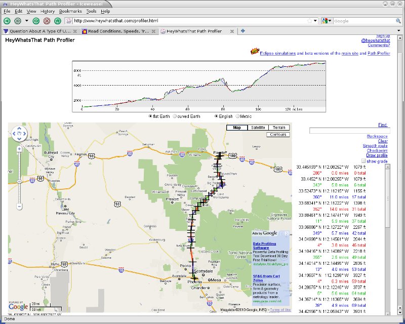
I believe he is referring to a cross section map. You would be viewing the road as seen from a 90 deg angle off the side of direction of travel, interposed on and within topographics. You would view the highway map, much the same way as when you drive down a road in your car, and watch as a train runs on a railroad track along the side of the highway parallel to your car's direction of travel, except in the 3d cross section map, any object between "you" and the route become transparent.
IP: Logged
12:22 AM
IMSA GT Member
Posts: 10720 From: California Registered: Aug 2007
I believe he is referring to a cross section map. You would be viewing the road as seen from a 90 deg angle off the side of direction of travel, interposed on and within topographics. You would view the highway map, much the same way as when you drive down a road in your car, and watch as a train runs on a railroad track along the side of the highway parallel to your car's direction of travel, except in the 3d cross section map, any object between "you" and the route become transparent.
That is correct. I just don't know how it would be accomplished. Bing maps allows you the "birds eye" view of cities but it would be interesting if they actually had a ground level map that showed the gradual rise in height of the different States in relation to sea level.
[This message has been edited by IMSA GT (edited 08-14-2010).]
IP: Logged
12:28 AM
spark1 Member
Posts: 11159 From: Benton County, OR Registered: Dec 2002
A State engineer in Arizona had a floor to ceiling 3-D topo map of Arizona on one wall of his office. Each mountain top radio site was represented by a pin and colored string was strung between the pins to show the interconnecting microwave paths. Very impressive in the days before computerized terrain maps. The longest State microwave path then was 130 miles, from Mt. Elden near Flagstaff to Navajo Mountain in Utah. The map was about 8' high and 6' wide made from smaller plastic panels that were each about 2' x 2'.
IP: Logged
12:30 AM
Gokart Mozart Member
Posts: 12143 From: Metro Detroit Registered: Mar 2003
That is correct. I just don't know how it would be accomplished. Bing maps allows you the "birds eye" view of cities but it would be interesting if they actually had a ground level map that showed the gradual rise in height of the different States in relation to sea level.
I suspect it will be in the public domain before too long, but DoD does quite a bit of that sort of thing already, especially in ocean bottom mapping, which has to show subsea mountains and valleys as well as waypoints in the traditional plane, and in reverse, regarding submarine routes under the ice of the Artic circle. On a smaller scale, it is done in directional and horizontal drilling of deep oil/gas wells, as they have to map progress left/right and up/down all at the same time. Showing more than 1 dimension at a time would be tricky, but I suspect it could easily be done by 1st flying the route with a helicopter using both terrain following radar and side scanning sonar at the same time to present a combined computer generated image of any route on to a computer screen or hand held--IF that technology has evolved enough to be able to present it in both a realistic and real time atmosphere..
[This message has been edited by maryjane (edited 08-14-2010).]
IP: Logged
12:52 AM
williegoat Member
Posts: 20783 From: Glendale, AZ Registered: Mar 2009
We used to construct profile maps when I was in the Army and used elevation lines. If it wasn't done correctly, it was skewed and distorted but if done correctly, it was a useful tool.
We're looking at houses in Oregon to buy when we sell our present house and move out there. I use Google Earth's view feature on the right side of the map and like my profile maps, it is a little distorted but still fairly accurate. When they put it on GPSs, it will be a great tool.


 Thanks!