Stores around Houston already running out of bottled water, chips, canned meat and bread and this is going to be a little one with just lots of rain here. It ain't going to be the end of the world.
How bad are they saying its gonna be? First one since 08' or something? 20 inches of rain inna day?
Hope its nothing serious...
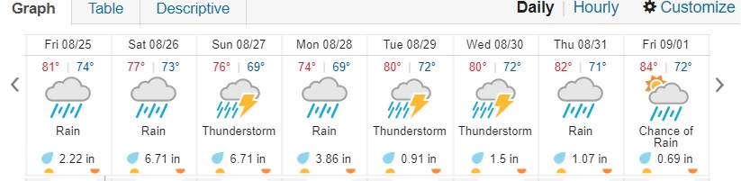
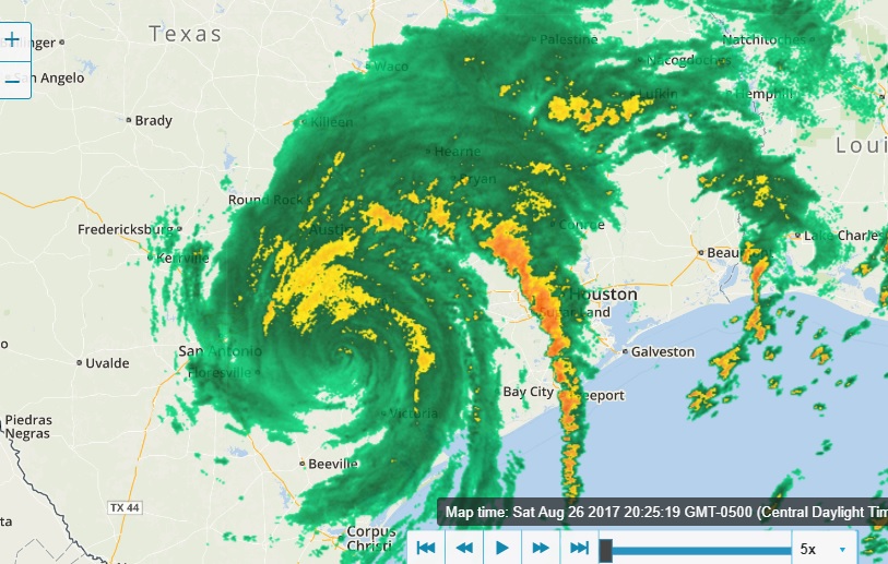
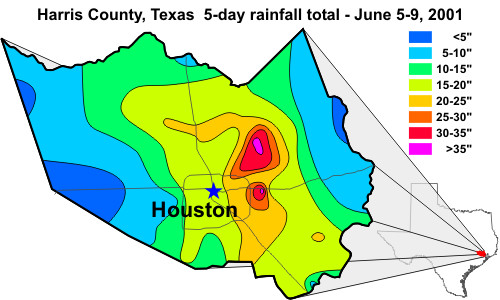
Not 20" in one day, but over the course of several days. It's now a minor cat1 hurricane but is now forecast to be Cat 3 right before it hits the coast, and will rapidly drop intensity back to Tropical Storm category, but it's forecast to move inland about 80 miles, make a NW loop and go back and sit over Corpus or any other town on the coast and drop rain all over SE Texas for 3 days. TS Allison did the same thing in '01 and dropped 30+ inches on Houston in the 3 days it hung around. TS Allison rainfall totals:
Current prediction for Harvey: "Rain: All of our top models are predicting that Harvey will dump more than ten inches of rain in a 5-day period in coastal Texas near where the center makes landfall. Some areas will likely receive 2 – 3 feet of rain over a 7-day period. Harvey has the potential to cause very serious flooding in such highly populated, flood-prone regions as the Austin-San Antonio corridor and the Houston metro area."
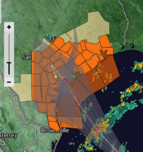
Storm surge is not expected to be as great as Hurricane Ike, but the real danger is going to large amounts of rain on a flat coastal plain, where run off is going to be slow. Current projected path; subject to change at any time:
[This message has been edited by maryjane (edited 08-24-2017).]
If you still live in Cleveland,TX. It looks to be where most of the water is headed. Do you have a boat loaded with milk and bread?
Yes to the first ? and no to the 2nd ?
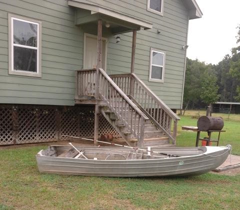
Everything is gassed to full and I just put 5 gal of diesel in the tractor in case we have to ride it to high ground. House will be fine..top of 1st finished floor is a full 6' above grade and I've never had flood water in the yard. Getting in and out of the property is the problem. I do have a small alum boat for that tho. Have my generator ready. Will have to put my welders and air compressor up on something in the shop if water gets very high tho. Beyond that..insurance.
MJ, the gas station by my house has a line several blocks long... reminds me of South Florida.
I don't get why people here in San Antonio are freaking out... all they're going to get is rain, and probably flooding. We won't get any hurricane-force winds this far out... people are just acting crazy.
MJ, the gas station by my house has a line several blocks long... reminds me of South Florida.
I don't get why people here in San Antonio are freaking out... all they're going to get is rain, and probably flooding. We won't get any hurricane-force winds this far out... people are just acting crazy.
Luling (just 60 miles East of San Antonio) is now forecast to get 2' of rainfall..that's feet not inches.
I will endeavor to keep the board informed as this thing plays out...
This morning at my place, I'm seeing a light but steady surface wind alternating from North to East back to North with dark clouds in the South moving from South to North. Lots of banding in the North. Pretty typical of a large storm's effects 12-16 hrs pre-landfall. I can't describe it, but you can feel it in the air. It's coming...
from a professional fisherman on another forum--sea bouy data at Aransas Pass which is North of Corpus Christi Tx and currently still more than 100 mi from eyewall:
Location: 26.968N 96.694W Date: Fri, 25 Aug 2017 13:50:00 UTC Winds: N (10°) at 35.0 kt gusting to 42.7 kt Significant Wave Height: 21.7 ft Dominant Wave Period: 13 sec Average Wave Period: 8.8 sec Mean Wave Direction: ESE (117°) Atmospheric Pressure: 29.39 in and falling rapidly Air Temperature: 80.6 F Dew Point: 77.2 F
Unless there is solid cloud cover at dusk, there should be an interesting sunset. Ike made landfall around 11pm and the sunset that day was spectacular.
[This message has been edited by maryjane (edited 08-25-2017).]
Batten down the hatches! Be safe and hope it doesn't get to crazy out your way. You could always call Fats to pick you up in that big fancy boat of his.
Batten down the hatches! Be safe and hope it doesn't get to crazy out your way. You could always call Fats to pick you up in that big fancy boat of his.
Moved my own up next to the back steps this morning. As Burt Gummer once said "This time..We're ready for ya"
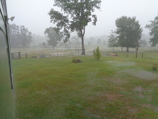
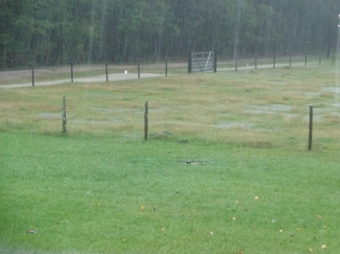
Other than intermittent rain and a few minor wind gusts, today was pretty calm.
Now a Cat 4 storm. I am very glad it so far south of me, but pray for those in that region. Tomorrow morning is apt to look very different all over SE and parts of E Texas.
No oars..just 2 paddles. Fishing rods are put in the shop.
I know of lots of farmers/ranchers that sent their families out of the coastal bend area toward SA.
Wind has picked up here in the last hour. Nothing threatening, just a steady E and ENE wind, probably 8-10 mph, maybe a little more. I don't expect to see more than 20-30mph sustained winds here and probably won't be until tomorrow morning.
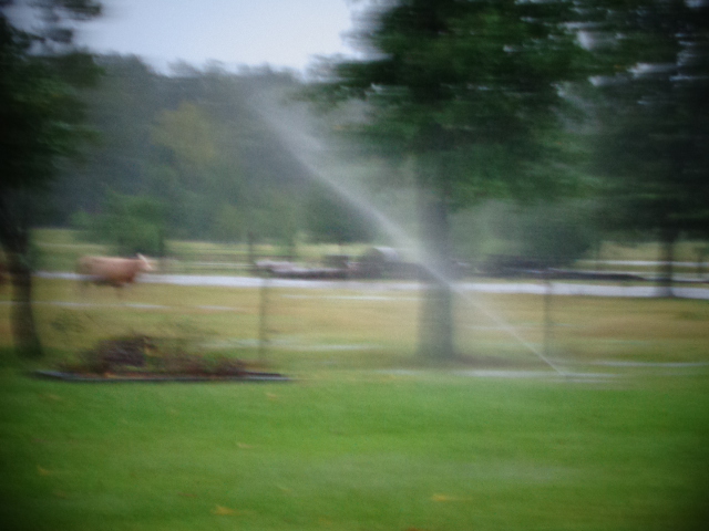
All that have calves are in the smaller pastures up north of and right behind the house. The rest of them better find a tree to get under. Gates to the East side are all open so those can make their way to the south side pasture west of the pond if they want to. I'll bring them up myself once the river rises..IF it rises.
Look on the bright side. Maybe some of the beaver will drown.
With you in spirit, Don.
One can only wish, but usually, the opposite is true. When the river gets up, that's where the big permanent beaver population resides, and they get driven out up into the creeks and ponds on higher ground. That's where mine always come from. Also how I have always gotten alligators from. They both just swim across the flooded pastures and take up residence in my ponds. And of course, my big catfish swim out into the pastures and follow the water as it recedes back down into the river channel. Ain't nothin I can do to prevent any of that except restock the ponds with fish later.
Hopefully, this time none of that will be an issue. Looks like everything but outer bands is staying to the south and west of Houston region.
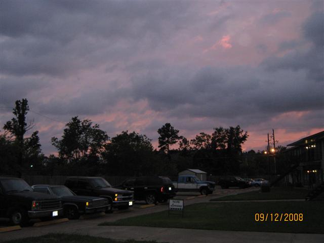
Ike was so much different. I took these pics the evening before--sunset Sept 12 '08:
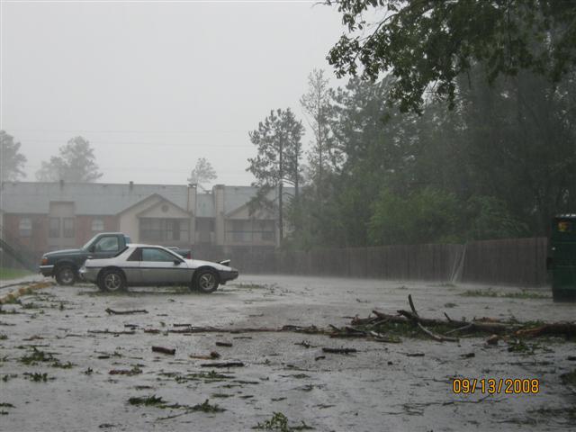
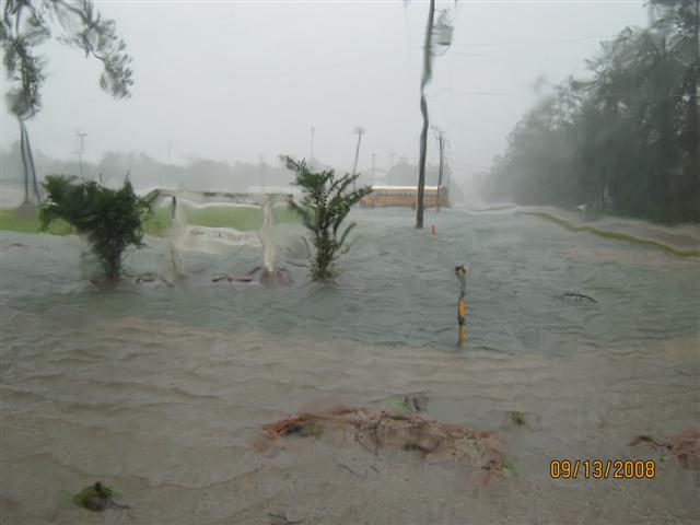
Just 10 hrs later, right after sunrise Sept 13 '08 from the same parking lot from different direction:
One can only wish, but usually, the opposite is true. When the river gets up, that's where the big permanent beaver population resides, and they get driven out up into the creeks and ponds on higher ground. That's where mine always come from. Also how I have always gotten alligators from. They both just swim across the flooded pastures and take up residence in my ponds.
So what you're saying is that wet beavers are your biggest problem?
( Follow along in O/T for a while and that seems to be a recurring theme )
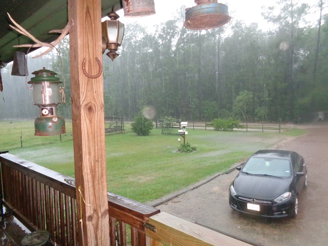
I'd have to sleep out with the cows. As much trouble as that car has been, my wife loves it. (radio is currently out on it..going to take it back in as soon as this Harvey mess is gone. They called yesterday to say they had the replacement and to bring it on in. It works fully, except it will only receive the 1-2 strongest stations no matter where you are--replaced the antenna 2 weeks ago and it didn't help)
We've been under numerous tornado warnings "take shelter now!" today, with 2 of them being for North Cleveland and movement in my direction, but I never noticed anything different here. N. Cleveland is 6 miles SE of me. Rainfall stands at 7" now since about 7am. Seems to be a lull or we're between the outflow bands right now, but I can still hear thunder rumbling. I've seen worse.
[This message has been edited by maryjane (edited 08-26-2017).]
We had our first flood since I've lived here a few months ago. My front yard was a lake but my foundation is high enough that no water made it in, a forum member who lives pretty close wasn't so lucky. I don't remember how many inches it took but in front of my house it overwhelmed the drainage(4ft deep ditches on both sides of my street) 3 out of the 4 people down stream from me got 4+ inches in their houses, worse in other parts of town.
Hoping that what you've seen previously stays as the worst to. Best wishes Don.
------------------ Ron
Isn't it strange that after a bombing, everyone blames the bomber, his upbringing, his environment, his culture, his mental state but … after a shooting, the problem is the gun.... Open your frigg'n minds, think about all the other tools that can be made into WMDs.
I sincerely hope that life is never discovered on another planet because, sure as hell Progressives and Socialists will want to send them money.
A buddy of mine on another forum was telling me they ran out of gas/propaine and water by 9am.. people are nuts. So all the vehicles will be in 2-3 foot of water but will have a full tank.. no one bought tall jackstands or ramps to get the vehicle higher ..
Still a very well formed storm system. Seeing/hearing non-stop thunder & lightning right now, but not much wind or rain. I'm glad I'm North of Hou and not on the south or SW side.
Originally posted by maryjane: I'm glad I'm North of Houston and not on the south or SW side.
I have been too busy to pay attention. I did hear that it is going to go back over the Gulf of Mexico and gather more ammunition (moisture) and then dance north east.
Maybe. Nothing's for sure with this one. The emergence back into the GoM 'could' happen, but so far model guidance on that is minimal.
Harvey has drifted east-northeastward since the last advisory. While the model guidance is not in great agreement, it appears that the cyclone will drift southward or southeastward during the next couple of days due to the distant influence of a trough digging into the eastern United States. After that time, a building ridge over the Gulf of Mexico should cause Harvey to drift generally northward. The new forecast track is similar to the previous track and lies near the consensus models. At this time, the forecast track keeps the center of Harvey inland, as there is not enough agreement between the models that the center of Harvey will actually emerge over water.
Harvey should continue to weaken to a tropical depression during the next day or so as the cyclone remains inland. As the center nears the coast, it is likely that the cyclone will maintain that status for several days as a large amount of the circulation will be over the water. By the end of the forecast period, the system should be far enough inland so that Harvey will again weaken. An alternative scenario is that Harvey could re-intensify if the center emerges over the Gulf.
I don't think I've ever seen a hurricane stay in one place for so long.(I haven't really played attention to very many)
Moving, but very slowly. Meandering is a better description.
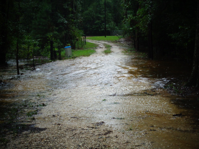
Things are serious here at home. Made our way out this morning, but no where to go. Roads flooded in both directions so we returned home to ride out whatever comes. I have dumped over 20" of water out of the rain gage since Sat morning. It had run over twice so I'm not sure what the actual total is. The river is now out of it's bank, and in the back pasture. Our only way off the property, which I went thru in the truck. If we get a hour's break, that water will go down and I can get Jane's car up on a high hill but will have to hurry. Erosion is making that crossing narrower by the hour.
And, as if there wasn't enough water coming down, I found it more than a little ironic that the water treatment plant decided this morning was a great time to pump itself down.
Hope your doing good down there. looks like we get some leftovers up in St.louis. Don't know what the record rain fall is for a 3 or 4 day storm is, but this one has to be in the running.
Hope your doing good down there. looks like we get some leftovers up in St.louis. Don't know what the record rain fall is for a 3 or 4 day storm is, but this one has to be in the running.
HOUSTON - Voluntary evacuations are expected to be issued for people living near the Addicks and Barker reservoirs as officials said they plan to release water from them Monday morning.
Col. Lars Zetterstrom of the Army Corps of Engineers said water will likely be released from the Addicks Reservoir beginning at 2 a.m. and from the Barker Reservoir at 11 a.m. The release will cause a rise of 4 to 6 inches per hour in the Buffalo Bayou and will cause more water to flow both upstream and downstream. More News Headlines
Harvey aims for second landfall Tuesday Curfews in effect for Houston-area cities due to Harvey High water locations in Houston area Tracking Harvey: School delays, closures
Homes could be impacted by 2 p.m., Zetterstrom said.
"This flood event will exceed the 2016 tax day flood elevations," Zetterstrom said. "Structures will be impacted upstream from both locations; the number of structures affected will depend on weather conditions."
Zetterstrom said the dams are performing as designed after Tropical Storm Harvey dumped record amounts of rainfall on Harris County. He said that the release is needed to reduce the risk of further flooding.
The nation’s fourth-largest city is inundated by floodwaters from the aftermath of Hurricane Harvey, and there’s no end in sight. On Sunday, The Weather Service predicted that parts of Texas could receive nearly 50 inches of rain before the storm ends.
[This message has been edited by texasfiero (edited 08-27-2017).]
Wow! That is just a crazy amount of water. We went thru the flood of 93 and that was mostly heavy winter thaw and big time spring rains. To get that much water in a few days is nuts.


 .
. ?
?


 .
.