Preface. This is going to be a lengthy post, or series of posts. It's a complicated and decades old subject and one that has the potential to touch all of us. It already has, in the form of higher fuel prices, consternation over the innundation of New Orleans, and what has happened afterwards. It's going to get worse at some point in time--much much worse. It may not happen in my lifetime, as I'm nearly 56 yrs old, but you younger folks will undoubtedly see it happen.
This is a subject I've been following and have been very interested in for about 3 decades. The story goes much further back than that, and tho I've been away from South Lousiana for about 10 yrs now, the recent events, Katrina in particular, have rekindled my interest. I want to thank HostKansas & Cliff in advance for making it so easy to post the images I'll be showing in the next few posts. Since most of us haven't been on the backroads of La, pictures will play an importantpart in this thread. A lot of this would be difficult to understand without the visual aids.
I lived in Cajun country from 1977 til 1995, working in the oil fields. It involved a lot of driving, mostly in rural areas, and a fair amt of spare time while on jobs. The spare time allowed me to sight see more or less, in the immediate areas I happened to be in at the time, and I took full advantage of it. I, like most folks (men anyways) have always been awed by big endeavors, and there is no larger endeavor in the U.S. than the containment of the Mississippi River. It has taken us, in modern times, about 120 yrs to get where we are now, and you see what that time $$ and effort has wrought. I've driven the levees, both inner and outer, from Morgan City in the south, up thru Morganza and ending at Old River(OR)--along the Atchafalya River(AR). In most places, there is a gravel road atop the levee and you are allowed to drive along it. Remember those names--Atchafalya and Old River. There is not a more important, precarious, or potentially dangerous juncture anywhere else in the country, for it is here, that the USACE (U. S. Army Corps of Engineers) has built what is known as the Old River Control Structure(ORCS). It's purpose-and only purpose, is to prevent the recepient of water from the largest drainage basin in the world, from doing what it has done for thousands of years--take a more direct course to the sea. This recepient, is the Mississippi River(MR). The more direct route, is a short and little known river named Atchafalya. Between the two stands a steel and concrete structure weighing tousands of tons, with anchor pilings driven deep into the earth. It's not enough. But, I'm getting ahead of myself. We need to go back in geological time. Not too far, just to the last age. (Now, I'm not a smart person, so I am pasting the next paragraph from a USGS site, but it explains it pretty well)
"The Quaternary Period is the youngest division of the Cenozoic Era. It is divided into two epochs; the Pleistocene and the Holocene. The Pleistocene, from 1.6 million years ago to 11,000 years ago, saw the evolution of human beings. The end of the Pleistocene is marked by the last of the great Ice Ages. The Holocene refers to the 11,000 years leading up to and including the present. We are living in Holocene time! The geologic features from this time period include the results of recent volcanic activity, such as Crater Lake, Valles Caldera, and The Snake River Plain, as well as recently deposited sediments, like The Mississippi Delta and The Central Valley of California."
Let's look at Louisiana-especially South La.
The entire area at the southest part of the state was formed during the Quarternary Period. It has taken over 1.5 million yrs to build up South La.
How?
"Look at a map of the state of Louisiana and you can see it is shaped something like a boot. Over the course of many millennia the bottom half of that boot has been created by the Mississippi. Southern Louisiana is built entirely of river sediment carried by water from as far away as the Rocky Mountains. As the Jefferson River gushes down a Montana mountainside it picks up little bits of that mountain and carts them off to the Missouri River. As the Wabash flows through prime Indiana farm land it picks up some of that land and carries it to the Ohio River. The process is cumulative until finally, the Mississippi, loaded with two million tons per day of washed away mountain and farm field, reaches sea level and slows down enough to unburden its load in southern Louisiana.
To build up all of southern Louisiana, the Mississippi has had to move around. Every couple of millennia it takes a major turn, abandons it's old channel, and finds a new one. The last time this happened was at the site where Donaldsonville now sits. Bayou Lafourche used to be the Mississippi. The next time this will happen will be at Old River.
It's during floods that the river deposits sediment to build up the surrounding land. Sediment, carried by the river current, settles out as the water slows down. When sediment laden floodwater breaches the river bank it slows down and the heaviest sediment is deposited nearest the bank. Likewise when the river reaches sea level it slows and sediment is deposited in the channel. Together these actions work over the course of centuries to raise the river up above the surrounding countryside. Southern Louisiana, as we noted, is composed entirely of river silt which slowly subsides under its own weight. The land farthest away from the river doesn't receive enough flood sediment to offset this subsidence and it sinks. Over the course of geologic time the river rises up on its own sediment as the surrounding land sinks under its own weight. This process eventually produces a difference in elevation between the two that gravity will not tolerate. One day (in human time), during high water, the river finds a weakness in it's natural levee and within hours a new river channel emerges."
To be continued..
IP: Logged
12:24 AM
PFF
System Bot
sostock Member
Posts: 5907 From: Grain Valley, MO Registered: May 2005
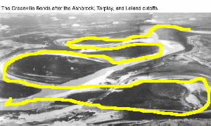
Ok, S. La has been built up over a period of thousands of years by the Mississippi River. The river, as stated above, has moved around a lot in it's long history. Where Bayou LaFourche now placidly runs, the mighty Mississippi once rolled. Anyne who has ever flown north/south over the river knows it is not very straight. It's full of bends, switchbacks and oxbows. If you had a giant Fiero boat, it would be a blast to drive. It has probably always been this way. To give you an indication of this, let's look at another picture. This is the Greenville Bends area. It is actually in Mississippi, but is a good example to show how the river slows down, and anytime water slows, it drops it's suspended sediments. In the early part of the 20th century, cutoffs were dredged between the bends. A straight line distance between the head of the first bend and the toe of the last bend measured only 15 miles, but because of the great meandering bends in between, it was 50 miles by river. The cutoffs, allowed the river to flow faster, carrying it's sediment further south. It also shortened travel time, allowed the river to carry more water at a faster rate, and thus tended to help prevent flooding. The yellow line represents the original course of the river, prior to the cutoffs being excavated.
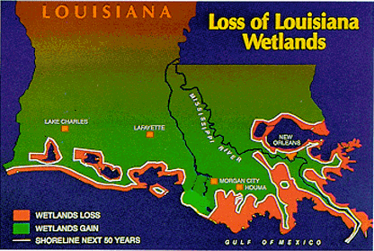
Another important aspect of delta building is floodwater expansion. As the water spreads out across a floodplain, it drops it's rich nutrients and sediments. As this occurs in a given course over a period of hundreds, or thousands of years, the floodplain gradually builds up, usually in the form of a lobe. As the terrain builds up, the river will begin to seek a new course, on a steeper gradient (slope) and lower elevation. The old river bed is usually left as a slow moving or stagnant stream, known as bayous in La. Among the bayous that once were the home of the MR are Bayou Lafourche, Bayou Teche (I lived and fished on this bayou in Port Barre La), Cocodrie, and Bayou Plaquemine. This constant change results in the birdsfoot geography we see in the delta of La. The MR doesn't exit to the gulf thru one channel. It empties as a series of small channels, each carrying, then dropping it's own sediment-or they used to anyway. Man changed that. If you were to draw a solid horizontal line east & west just north of New Orleans, everything to the south of that line is really marshland, interrupted by solid ground in places. The locals call these islands and name the towns as such, even tho they are interconnected by asphalt roadways. Pecan Island, Avery Island (Where McIllhenny Tobasco is made), Honey Isand etc.
Ok, the MR used to meander about, flood everywhere, and spread out into these low lying areas and drop it's sediment. Now, it's been straightened, dredged, levied and it doesn't do it any more. Because of this, the delta is now shrinking and has ever since man put his greedy little hands on the river in the 1890s. Actually, before that, but that is when the feds really first got into it.
now, hopefully people will understand somewhat the importance the regaining the wetlands again. i knw they have talked baout it on the news, but ths is the first ive heard of how it all works. thanks
There is a Lansat image here. There is a very green swath running more or less north south just to the left and parallel to the MR. This, is the Atchafalya Floodway. It contrasts sharply with the dead area alongside the MR, where rich sediment has no longer been dropped. If you have ever driven on I-10 between Lafayette and Baton Rouge, you have passed over this floodway--the bridge is about 12 miles long if I remember right. I mention things such as sediment buildup, cutoffs and levees because they are an important part of this subject, and I promise I will eventually get to the thread subject line. Like I said, it's a complicated story. A good bit of history is necessary to make it all make sense, so lets see how man screwed up what mom nature did so well for so long.
1. The 1st levees were built by the French starting in 1717, only 3 ft high and were to protect N.O.. Most were built upon existing sandbar buildups, and doubled as roadways.
2. When the US acquired La thru the Louisiana Purchase, the Americans began moving into the fertile delta areas rather than the higher ground--mostly to begin cotton production. They extended the levees northward-and southward, usually right on top of the French built levees. (This tradition has continued up until today)
3. Each farmer, or plantation owner built his own levee, until it began to be evident that combined efforts were more productive. In 1849, Mississippi and La landowners negotiated with the federal govt to make a land trade-or grant. The federal govt transferred title of the land, including swampland to the states, who then sold the land and the revenues were to be used for flood protection construction. Levee disticts were drawn up within each state, and levee boards formed. These boards had power of emminent domain, taxation, and all the other crap that went along with any govt program. They were very loosely organized and adjacent district boards often clashed, especially when a levee on one side of the river cased flodding of another district on the opposite shore.
4. 1824. The Supreme Court decrees that the Federal Govt has control of all navigable waters within the USA. Ogden vs Gibbons. This sets the stage for what we have today.
5. 1850. The 1st study called Report Upon the Physics and Hydraulics of the Mississippi River is completed and sent to congress.
6. The Civil war pretty much stopped any effort to do much on the river for a period of 10 years.
7. 1870s. Oceangoing ships were having a hard time navigating the mouth of the river at what is known as Head of the Passes. The completion of the Erie Canal in the north resulted in more wheat, corn and cotton being exported from that region than could be put aboard ships out of New Orleans. The fight (struggle) was on to open the MR to navigation, as 47 vessels were now stranded aground off the La coast at the mouth of the river. Enter James Eads, a bridge builder from St Louis, with an idea to build jettys out into the gulf at the South Pass, , thus confining & increasing the velocity of the river and allowing it to scour the bottom to a deeper depth. He was opposed by a group of engineers who wanted to duplicate the succes of the Erie Canal. The argument went on for over a year, and eventually Eads built his jettys and the river did it's job. Completed in 1875, to a depth of 26 ft X 200 ft wide. New Orleans was now a port with a global connection.
8. Eads goes before congress with his report, and as a result, the same idea is implemented (after a long congressional fight) to keep the rest of the river to a navigable depth by the use of levves to chanel the river and induce scouring of the bottom. The proposal is not introduced solely as a flood control measure, to get the support of the rest of congress outside the Mississippi Valley region. Strapped for cash after the Civil War, Northeners aren't real keen on spending Federal $ on the south. After months of partisan wrnagling, The Mississippi River Commision is formed. The US Army Corps of Engineers is given (takes) control, as the MRC is a federally mandated entity. It's 1879. The MRCs federally mandated job is to keep the MR open to navigation, pursuant to Gibbons vs Ogden--flood control is a secondary goal. Levee systems are began from New Orleans to Cairo Ill.
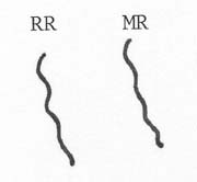
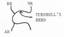
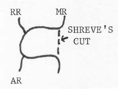
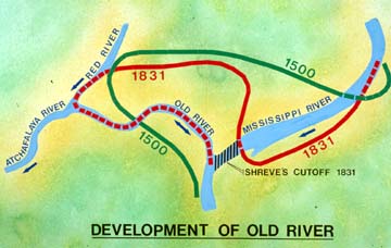
Now, we back up, to reaquaint ourselves with the biggest (and deepest) player in the story. The Atchafalya River. Up to the 15th century, The Red River (RR) and Mississippi River (MR) were separate rivers, more or less parallel. The Red River ran from what is now New Mexico , accross the top of Texas, all the way to the Gulf of Mexico.
The MR made a loop to the west, and the Red River became a tributary of the Mississippi River. This loop became known as Turnbull's Bend. From this point south, the old course of the Red River became the Atchafalya River. It became a distributary of the MR during times of flood, and has at times in history, become the main channel for the Mississippi.
BY 1778: The entrance to AR was blocked by a log jam. 1831: Capt. Henry M. Shreve, founder of Shreveport and a world renowned river engineer, dug a canal through the neck of Turnbull's Bend. The 1st manmade cutoff to affect the MR.
Over time, the northern part of Turnbull's bend filled in, and the southern part became known as Old River and connected the Mississippi, the Red, and the Atchafalya Rivers.
[This message has been edited by maryjane (edited 10-02-2005).]
Thanks Nick-a fresh pot of coffee and a re-boot so I'll continue.
Ok, from the late 1800s into the new milenium, the Mississippi River Commission adopted a "Levees Only" policy of flood control. The USACE built levees up to heights of 22 ft in many places. Spring floods came and went, most not too damaging, and the Corps was encouraged. Some dams & reservoirs had been built in the northern tributary basins, and this undoubtedly helped some. The Corps was learning as they went and did begin to understand how the river hydrology worked. Already in place was a system of gages along the river, with which could be extrapolated the flood stage down river, while the flood was still in it's early stages in the Missouri, Ohio, and Illinois basins. Fuse plug levees were designated along the entire upper & lower basins, which meant they would be blown if the levees could not hold all the water.
In 1922, a fairly good test of the levees came. The levee system held with only 2 exceptions. One levee failed at Natchez, another, south of New Orleans at Poydras. The people and officials of New Orleans came to believe that the levee failure at Poydras saved their city, and lobbied congress and the MRC to build a spillway south of NO at Pointe la Hatchie, which sits about 40 miles south of NO out on the long finger leading to the end of the world-Venice La. (One of my least favorite places to go). They got their wish, and 11 miles of levee was lowered. Subsequent tests at the USACE scale model laboratory concluded the 1922 breaches only dropped the level of the river at NO 1.6 ft. New Orleans was never really in danger it seems.
1927. The Big One. "The 1927 flood left a disastrous impact upon the entire 1,250,000 mile river drainage. The unprecedented rainfall began over the whole basin in late summer 1926, and didn't abate until the summer of 1927. The flooding began at Memphis in the fall of 1926 and it was late August of 1927 before the last of the flood waters flowed into the Gulf below New Orleans. The levee system was decimated with over 120 crevasses (Fig. 1) and 165 million acres were inundated. There were 246 fatalities and over 600 thousand people were made homeless. The total damage was estimated at $230 million." A LOT of bad things happened during this flood, and sometimes the worst of human nature surfaced. This was the 20's and racial bigotry knew no bounds. Blacks were rounded up and put to work on the levees, and left there overnight for weeks, while the whites went home to their families. "Work or drown" they were told--and much worse.
Another important event was the dynamiting of the levee at Carnveron, south of NO. Remembering the 1922 flood, and the levee break at Poydras, NO had the levee blown, with the blessing of the MRC. It flooded thousands of homes in St Bernard Parish, and hostile feelings toward NO exist there to this day. New Orleans still flooded. "The �27 high water tore the valley apart. On both sides of the river, levees crevassed from Cairo to the Gulf, and in the same thousand miles the flood destroyed every bridge. It killed hundreds of people, thousands of animals. Overbank, it covered twenty-six thousand square miles. It stayed on the land as much as three months. New Orleans was saved by blowing up a levee downstream.* Yet the total volume of the 1927 high water was nowhere near a record. It was not a hundred-year flood. It was a form of explosion, achieved by the confining levees." *Now concluded to be an erroneous supposition.
This is the flood against which all future floods would be measured. It is also the flood which ended forever, the Levees Only policy. Out of this flood came the Flood Control Act of 1928, which basically took all the power away from the MRC, and gave it to the USACE. The MRC still exists, as does the levee districts, but the Corps now calls all the shots.
Aside from rebuilding the levees, the USACE was mandated to figure out some way to both control, and contain, the river- thru floodways. The Corps looked to the future to try to figure what to prepare for. The magic # is 3,000,000. Not dollars. 3 million cubic ft of water/second. This is known as the Project Flood. The ultimate flood. 25% above the flow rate of the 1927 flood just north of Baton Rouge La.
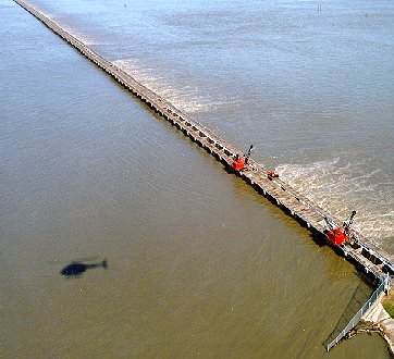
The 1st control structure to be built, was the Bonnet Carre Spillway just about 32 river miles north of New Orleans. An engineering marvel of it's day, it's simple in it's operation. Pronounced Bonnie Carrie. There are 350 bays in the structure, each 20 ft wide. 5 miles long. In each bay, are 20 creosote timbers, with a total of 7000 timbers. There are 2 cranes, which traverse the top on rails, pulling the timbers. The timbers are laid horizontally accross the top of the structure for future reinstallation. It takes 36 hrs to pull all 7000 timbers, tho there IS an emergency method in which 20 timbers can be removed at a time, reducing the time for full opening to 3 hrs. At full opening, the strucure releases water at 250,000 cf/s into Lake Ponthartrain. Survey work started in 1928, and completed in 1931. 3 yrs-a heck of a job. The site was chosen because this has historically been the location of 7 levee failures in the past. Nature pointed the way.
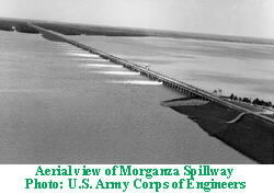
The 2nd to be constructed in La, was the Morganze spillway, just south of Baton Rouge near False River. Completed in 1954, and capable of shunting 600,000 cf/s into the Atchafalya Basin, it has only been opened once. In 1973. Flooding occured all along the Atchafalya, clear down to Morgan City, with that port partially shut down due to high water as a result. Homes were flooded, crops lost, damage in the many millions of $. It absolutely had to be opened-but neither New Orleans nor any other town on the Lower Mississipi was in danger. ?!?
[This message has been edited by maryjane (edited 10-02-2005).]
IP: Logged
10:36 AM
lurker Member
Posts: 12351 From: salisbury nc usa Registered: Feb 2002
let's see if i understand where youre going with this.
so we've channelled the river to control flooding and keep the MR navigable. we've cut off the oxbows to do the same, and to straighten the river. consequences? the river drops less sediment at the delta, ans the gulf is carrying the delta away. the river drops less sediment along it's course, so that combined with monoculture, the fertility of the land is declining. meanwhile the land behind the levees is not building up, in fact it's sinking, below the river. prime real estate for subdivisions.
one day in the not-too-distant future, a storm or levee system collapse will result in a flood, perhaps the largest flood since biblical times, covering significant parts of Louisiana and Mississippi, causing massive fatalities and destroying infrastructure and the economy. New Orleans may cease to exist.
And they STILL want to rebuild there? Cart before the horse, it seems.Make sure it is as safe as possible, then re-populate...or is it too late? I am fascinated.
------------------ fierofetish.PFF'S self-confessed Snowbird!! Responsibility: the solution for our World's Dilemmas.. Yahoo messenger:nickcannspain MSN Messenger-nicholascann@hotmail.com
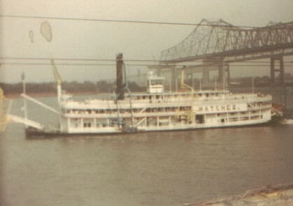
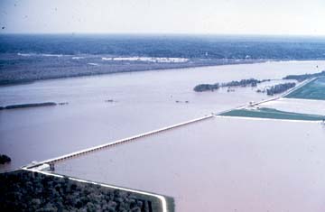
Not exactly. Before I go on, I want to explain about the levees themselves. A lot of people are under the impression that there is a lot of room for flood waters to expand on the Mississippi River before they reach the levee itself. This is true in the upper valley, but not between baton Rouge and the Gulf of Mexico. The following poor and old pictures, I (or my children) took in the early to mid 80s in Baton Rouge and New Orleans. The World's Fair was in New Orleans in 1984, and the following was taken there, when I took my children to it. This is the steamboat Natchez of course. I took this picture standing atop the Mississippi River levee. As you can see, there are power lines directly at head level to me--within the levee. Directly behind and below me, is the site of the world's fair. I believe it is now a convention center. The businesses are built up right to the levee, with some even outcropping over the levee, for a nice view of the river. Water is directly below me. If you are wondering about the bridge that appears to go nowhere-it didn't at the time. It was just being built.
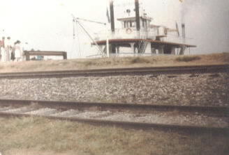
This picture, was taken in Baton Rouge the same year. We went over early one Saturday to go out on a day excursion boat. This is not a realsteam paddlewheel, but a diesel driven miniature just to scoot along the local river for tourists like us. Yes, I'm standing on the levee, with railroad tracks on it. I do not know what theflood stage of the river was, but it was summer, and I remember them saying they weren't allowed to take passengers out during high flow rates.
This was taken on the little boat, looking down the levee on the opposite side from the above picture. Not a lot of levee uncovered by water is there?
Not a lot to show scale here, but this is again a pic of the levee holding water out of the Capitol City of Louisiana.
My apologies for the poor images. They went to school on a lot of show & tell type things. You can see the businesses built up right to the levee especially in the Baton Rouge pictures. This also was the case at the World's Fair in NO. It is one of the reasons the levees aren't built up any higher. To do so, they have to also widen the base, and too many homes and businesses would have to be moved.
[This message has been edited by maryjane (edited 10-02-2005).]
IP: Logged
11:38 AM
PFF
System Bot
$Rich$ Member
Posts: 14575 From: Sioux Falls SD Registered: Dec 2002
And one more. This is still Baton Rouge. The boat skipper had pulled up close to a lock, which I 'think' is the Port Allen lock, so we could watch it operate as a boat used it. As you can see, there isn't a lot of flood protection visible down that canal or bayou.. Remember, it was on one of the canals in N.O. that the biggest part of the flooding and breach happened.
1973. Floodtime on the lower Mississippi. Not a particularly bad flood, but one that was more telling than any fortune teller's ball. For the 1st and only time since it's construction, the Morganza Spillway had to be opened to the tune of over 1/2 a million cubic ft of water PER SECOND!! Not to keep New Orleans or Baton Rouge from flooding.
Remember Capt Shreve had cleared the Red and Atchafalya rivers of a huge log jam in the 1830s. He cut Turbull's Bend. This connected the three rivers together.
"As time passed, AR became deeper and wider and began to capture more of the MR. During high water in the MR, water flowed west in OR and down AR. When RR was high and MR low, water flowed down AR and east through OR. 1880: AR was now large enough that there was only occasional eastward flow. AR continued to grow and capture more of the MR. 1953: By the late 1940s, the U.S. Army Corps of Engineers concluded that MR could change course to the AR bed by 1990 if it were not controlled. This observation came from studies that monitored latitude flow over the years.
Percentage of Latitude Flow Entering the Atchafalaya River 1850-1950 Year Percentage 1850 ---10.0 1900 ---13.0 1920----18.1 1940 ---23.3 1950--- 30.0
By this time, New Orleans was the 4th largest port in the world, tonnage wise. It still is. The industry between Baton Rouge and new Orleans reads like the Fortune 500 list--and then some. There's a nuclear power plant there, taking it's cooling water from the Mississippi River. The 2nd largest gasoline refinery in the country is there-drinking water like a huge camel. Every town from Baton Rouge to Venice gets it's fresh water from the river. If, the river takes it's new natural course, it goes down the deepest river in the world-the Atchafalya. 134 miles shorter travel to the Gulf.
"The Atchafalaya, continuing to grow, had become, by volume of discharge, the second-largest river in the United States. Compared with the Mississippi, it had a three-to-one advantage in slope. Around 1950, geologists predicted that by 1975 the shift would be unstoppable. The Mississippi River and Tributaries Project would be in large part invalidated, the entire levee system of southern Louisiana would have to be rebuilt, communities like Morgan City in the Atchafalaya Basin would be a good deal less preserved than Pompeii, and the new mouth of the Mississippi would be a hundred and twenty miles from the old. Old River Control was authorized in 1954.
The levees were raised again. What had been adequate in 1937 was problematical in the nineteen-fifties. New grades were set. New dollars were spent to meet the grades. So often compared with the Great Wall of China, the levees had more in common with the Maginot Line. Taken together, they were a retroactive redoubt, more than adequate to wage a bygone war but below the requirements of the war to come. The levee grades of the nineteen-fifties would prove inadequate in the nineteen-seventies. Every shopping center, every drainage improvement, every square foot of new pavement in nearly half the United States was accelerating runoff toward Louisiana. Streams were being channelized to drain swamps. Meanders were cut off to speed up flow. The valley�s natural storage capacities were everywhere reduced. As contributing factors grew, the river delivered more flood for less rain. The precipitation that produced the great flood of 1973 was only about twenty per cent above normal. Yet the crest at St. Louis was the highest ever recorded there. The flood proved that control of the Mississippi was as much a hope for the future as control of the Mississippi had ever been. The 1973 high water did not come close to being a Project Flood. It merely came close to wiping out the project."
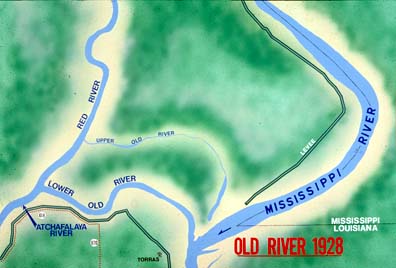
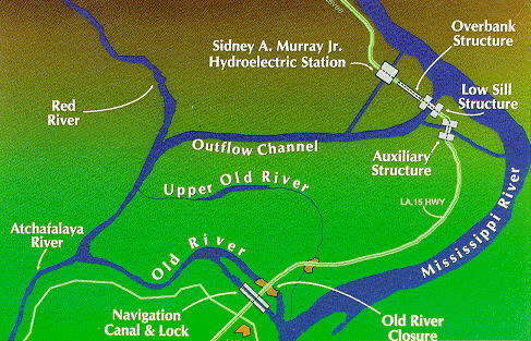
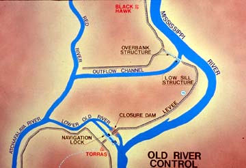
In 1954, congress mandted the USACE to do whatever was neccessary to maintain the 1950 levels of flow between the Mississippi and the Atchafalya. 70% flow to the Mississippi-30% to the Atchafalya-even during flood conditions. At Turnbull's Bend, where it had all started in 1837, the Corps built a 200,000 ton control device know as the Old River Control Structure.
The first thing they did, was to dam off the lower part of Turnbull's bend-which connected the Atchafalya to theMississippi. Then, they built what was known as the Low Sill structure. This is the 1st line of defnse, and it's thru this, that the 30% flow is diverted to the Atchafalya. A little ways away, is the Overbank Structure. This, is opened to let even more water into the Atchafalya Basin. At the site of the lower Old River, (now dammed off) a set of navigation locks was built to allow entrance to and from each river. The whole project was announced complete in 1963.
[This message has been edited by maryjane (edited 10-02-2005).]
IP: Logged
01:47 PM
Raydar Member
Posts: 40726 From: Carrollton GA. Out in the... country. Registered: Oct 1999
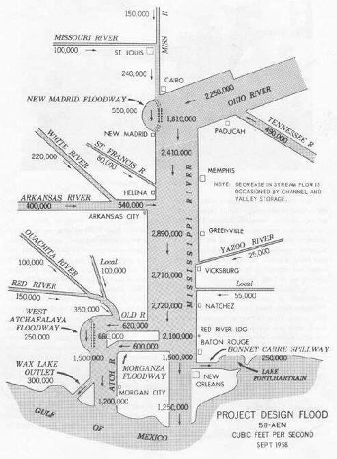
The USACE had planned for The Project Flood. 25% more floodwater than The Great Flood of 1927. The levees are now complete. Morganza is in place. Bonnet Carre' is in place. The Project Flood plan looks like this:
150,000 cf/s comes down the Mississipi River from the north. 100,000 cf/s flows from the Missouri River into the Mississippi. 240,00cf/s flows past Cairo. 2,250,000 more cf/s comes from the Ohio River. The Tennesee River dumps in 490,000cf/s. 550,000cfps is dumped off thru the New Madrid Floodway. Even so, 2, 240,00 cf/s flows past the bluffs of Memphis. The St Francis drops it's meager 80,000 cf/s into the Miss River. The White and Arkansa Rivers contribute a combine 540,00cf/s. The Yazoo spurts out 25,000 cf/s. The gage at Greenville Miss, shows a flow of 2,890,000 fpss. Due to channel width and valley storage, the Natchez Miss flow rate drops 2,720,00 fps. At Red River Landing, East, accross the Miss River from the Old River Control Structure, the flow is recorded at 2,100,00 fps, after the combined Low Sill and Overbank structure sends 620,000 fps down the Atchafalya Basin. Morganza, for only it's 2nd time in history opens it's 42 gates and sends another 600,000 fps down the Atchafalya. Morganza is a last resort option. It is to be opened only in the event a catastrophic flood is on it's way to the Crescent City of New Orleans.. Bonnet Carre' the eldest, lifts her 7000 timbers and sends 250,000 fps screaming into Lake Pontchartrain. There'll be no brown shrimp for seasons to come. New Orleans sees 1, 250,000 fps well within the capacity of her levees.
Meanwhile, to the west, with it's steeper gradient, the Atchafalya, even with it's 15 wile wide flood plain, One & 1/2 million cubic ft/sec are flowing toward Morgan City. 300,000 cf/s are dropped off at the Wax Lake and into the Gulf. Morgan City sees a flow rate of 1, 250,000 fp/s. This was The Project Flood.
In 1973, Morganza was opened. There was no project flood. No where near it. Why was it opened? To preserve the City of New Orleans. Not from a flood, but from being left high & dry. The Corp's crown jewell, the $200,000,000 Two hundred thousand ton Old River Control Structure was failing.
"At Old River Control on an ordinary day, when the stilling basin sounds like Victoria Falls but otherwise the country is calm and dry�when sandy spaces and stands of trees fill up the view between the structure and the Mississippi�an almost academic effort is required to visualize a slab of water six stories high, spread to the ends of perspective. That is how it was in 1973. During the sustained spring high water�week after week after week�the gathered drainage of Middle America came to Old River in units exceeding two million cubic feet a second. Twenty-five per cent of that left the Mississippi channel and went to the Atchafalaya. In aerial view, trees and fields were no longer visible, and the gated stronghold of the Corps seemed vulnerable in the extreme�a narrow causeway, a thin fragile line across a brown sea.
The Corps had built Old River Control to control just about as much as was passing through it. In mid-March, when the volume began to approach that amount, curiosity got the best of Raphael G. Kazmann, author of a book called �Modern Hydrology� and professor of civil engineering at Louisiana State University. Kazmann got into his car, crossed the Mississippi on the high bridge at Baton Rouge, and made his way north to Old River. He parked, got out, and began to walk the structure. An extremely low percentage of its five hundred and sixty-six feet eradicated his curiosity. �That whole miserable structure was vibrating,� he recalled in 1986, adding that he had felt as if he were standing on a platform at a small rural train station when �a fully loaded freight goes through.� Kazmann opted not to wait for the caboose. �I thought, This thing weighs two hundred thousand tons. When two hundred thousand tons vibrates like this, this is no place for R. G. Kazmann. I got into my car, turned around, and got the hell out of there. I was just a professor�and, thank God, not responsible.�
Kazmann says that the Tennessee River and the Missouri River were �the two main culprits� in the 1973 flood. In one high water and another, the big contributors vary around the watershed. An ultimate deluge might possibly involve them all. After Kazmann went home from Old River that time in 1973, he did his potamology indoors for a while, assembling daily figures. In some of the numbers he felt severe vibrations. In his words, �I watched the Ohio like a hawk, because if that had come up, I thought, Katie, bar the door!�
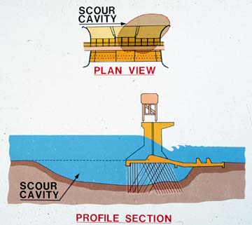
The water was plenty high as it was, and continuously raged through the structure. Nowhere in the Mississippi Valley were velocities greater than in this one place, where the waters made their hydraulic jump, plunging over what Kazmann describes as �concrete falls� into the regime of the Atchafalaya. The structure and its stilling basin had been configured to dissipate energy�but not nearly so much energy. The excess force was attacking the environment of the structure. A large eddy had formed. Unbeknownst to anyone, its swirling power was excavating sediments by the inflow apron of the structure. Even larger holes had formed under the apron itself. Unfortunately, the main force of the Mississippi was crashing against the south side of the inflow channel, producing unplanned turbulence. The control structure had been set up near the outside of a bend of the river, and closer to the Mississippi than many engineers thought wise.
On the outflow side�where the water fell to the level of the Atchafalaya�a hole had developed that was larger and deeper than a football stadium, and with much the same shape. It was hidden, of course, far beneath the chop of wild water. The Corps had long since been compelled to leave all eleven gates wide open, in order to reduce to the greatest extent possible the force that was shaking the structure, and so there was no alternative to aggravating the effects on the bed of the channel. In addition to the structure�s weight, what was holding it in place was a millipede of stilts�steel H-beams that reached down at various angles, as pilings, ninety feet through sands and silts, through clayey peats and organic mucks. There never was a question of anchoring such a fortress in rock. The shallowest rock was seven thousand feet straight down."
[This message has been edited by maryjane (edited 10-02-2005).]
IP: Logged
02:59 PM
Wht&BluGT Member
Posts: 1175 From: Waterford, MI Registered: Jan 2005
wow...love it.. Chants more more more.. feed my brain!!
------------------ Ferrari 308 GTB rebody on a modified 86SE chasis Soon to have a highly hooped up 3800SC..Ohh yeah baby!! I like a lil Whine with my meal when I go out to eat Rice Contacts _ AIM / Zildjianfx _ Yahoo / djdraggin Remember, always brush your milk, drink your teeth, dont do sleep and get eight hours of drugs.
There seems to be a recurring theme, here. And every time, it seems to make the situation worse. Am I misunderstanding?
Merely an observation. Don't mean to hijack. Please continue.
The USACE works under the direction of Congress and the President. New Orleans has always had a strong lobby in Washington and usually gets it's way when it comes to keeping the Port open and running.
I came upon this behemoth in my travels along the outer Atchafalya levee, but can't remember where now. It's unique, in that it "Walks" instead of having tracks. A large cam on each side picks the legs up, and you can just see the foot of the lower left. It was just abandoned in a field, and the landowner told me it had been there since he was a kid. The bucket was as large as a large dumptruck bed. It looked as tho they got thru with that portion of the levee and just drove off and left it. All the machinery was still inside as far as I could tell.
Hopefully I've got this sized down to fit now-coulda saved myself some typing had I been able to do it earlier.
I have to sleep now..........
Have to post attributation when i return.
[This message has been edited by maryjane (edited 10-02-2005).]
IP: Logged
03:55 PM
Vonov Member
Posts: 3745 From: Nashville,TN,USA Registered: May 2004
Really interesting stuff. On that last pic, either I'm missing something or hydrodynamics uses some math I'm not familiar with: Quachita River = 100,000 Red River = 150,000 Local = 100,000 total when all three meet: 350,000 ... all well and good. Next: White River = 220,000 Arkansas River = 400,000 Total when both meet: 540,000 Unless it just signifies the amount of max flow at those points, in which case some water would have to be slowed down. But if that were true, then the separate rivers couldn't flow as much as they say. Still doesn't make sense to me.
There is a note on the right side that says "Decrease in stream flow is occassioned by channel and valley storage". I'm not real familar with that area, but I do know that the Helena Ark region is pretty flat. These are projected flow rates for the Project Flood, (1927 flood+25%) which has not yet taken place, so I'm guessing the USACE is using computer models at best, tho that diagram is dated 1958. I have a newer flow diagram on a floppy somewhere, but it is too blurry to read the numbers.
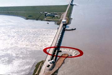
The flood of 1973 badly damaged the Old River Control Structure' s Low Sill weir. The sheer velocity and weight of the water from the Mississippi River had soured out 2 ton boulders on the inlet side and tossed them thru the structure to be rolled along the Atchafalya's flow. It ate away the south wingwall and sent it's remains out into the basin. On the discharge side, it had eaten out a footballfield size hole. The outermost steel pilings anchoring the structure lay exposed.
"Then, as now, LeRoy Dugas was the person whose hand controlled Old River Control�a thought that makes him smile. �We couldn�t afford to close any of the gates,� he remarked to me one day at Old River. �Too much water was passing through the structure. Water picked up riprap off the bottom in front, and rammed it through to the tail bed.� The riprap included derrick stones, and each stone weighed seven tons. On the level of the road deck, the vibrations increased. The operator of a moving crane let the crane move without him and waited for it at the end of the structure. Dugie continued, �You could get on the structure with your automobile and open the door and it would close the door.� The crisis recalled the magnitude of �the �27 high water,� when Dugie was a baby. Up the valley somewhere, during the �27 high water, was a railroad bridge with a train sitting on it loaded with coal. The train had been put there because its weight might help keep the bridge in place, but the bridge, vibrating in the floodwater, produced so much friction that the coal in the gondolas caught fire. Soon the bridge, the train, and the glowing coal fell into the water.
One April evening in 1973�at the height of the flood�a fisherman walked onto the structure. There is, after all, order in the universe, and some things take precedence over impending disasters. On the inflow side, facing the Mississippi, the structure was bracketed by a pair of guide walls that reached out like curving arms to bring in the water. Close by the guide wall at the south end was the swirling eddy, which by now had become a whirlpool. There was other motion as well�or so it seemed. The fisherman went to find Dugas, in his command post at the north end of the structure, and told him the guide wall had moved. Dugie told the fisherman he was seeing things. The fisherman nodded affirmatively.
When Dugie himself went to look at the guide wall, he looked at it for the last time. �It was slipping into the river, into the inflow channel.� Slowly it dipped, sank, broke. Its foundations were gone. There was nothing below it but water. Professor Kazmann likes to say that this was when the Corps became �scared green.� Whatever the engineers may have felt, as soon as the water began to recede they set about learning the dimensions of the damage. The structure was obviously undermined, but how much so, and where? What was solid, what was not? What was directly below the gates and the roadway? With a diamond drill, in a central position, they bored the first of many holes in the structure. When they had penetrated to basal levels, they lowered a television camera into the hole. They saw fish."
"After three and a half years, control was to some extent restored, but the extent was limited. In the words of the Corps, �The partial foundation undermining which occurred in 1973 inflicted permanent damage to the foundation of the low sill control structure. Emergency foundation repair, in the form of rock riprap and cement grout, was performed to safeguard the structure from a potential total failure. The foundation under approximately fifty per cent of the structure was drastically and irrevocably changed.� The structure had been built to function with a maximum difference of thirty-seven feet between the Mississippi and Atchafalaya sides. That maximum now had to be lowered to twenty-two feet�a diminution that brought forth the humor in the phrase �Old River Control.� Robert Fairless, a New Orleans District engineer who has long been a part of the Old River story, once told me that �things were touch and go for some months in 1973� and the situation was precarious still. �At a head greater than twenty-two feet, there�s danger of losing the whole thing,� he said. �If loose barges were to be pulled into the front of the structure where they would block the flow, the head would build up, and there�d be nothing we could do about it.�
A sign appeared on one of the three remaining wing walls: �Fishing and Shad Dipping off This Wing Wall Is Prohibited.�
A survey boat, Navy-gray and very powerful and much resembling PT-109, began to make runs toward the sill upstream through the roiling brown rapids. Year after year�at least five times a week�this has continued. The survey boat drives itself to a standstill in the whaleback waves a few yards shy of the structure. Two men in life vests, who stand on the swaying deck in spray that curls like smoke, let go a fifty-pound ball that drops on a cable from a big stainless reel. The ball sinks to the bottom. The crewmen note the depth. They are not looking for mark twain. For example, in 1974 they found three holes so deep that it took a hundred and eighty-five thousand tons of rock to fill them in.
"
Only by opening the 42 gates of Morganza was the structure saved from destruction. Also open, was the Lowsill, and the Overbank Structure at Old River. The highest recorded flow ever was going down the Atchafalya. The Atchafalya Floodway is approx 100 miles long, 15-25 miles wide. In 24 hrs, it went from a placid scenic swamp, to a rolling monster. The hwy 190 bridge just south of Old River was closed for fear it would collapse. Rail traffic was diverted to avoid crossing the high bridge south of 190. The western levee on the Atchafalya was breeched, flooding the town of Krotz Springs. Trucks were prohibited from using the I-10 bridge between Lafayette and Baton Rouge. For over 2 weeks, Morganza's gates stayed open. Business, farming, and industry from Old River to Morgan City was disrupted, including the Morgan City Port. I previously said the Atchafalya still deposits it's sediments because it's leveed diferently from the Mississippi. It's levees are far from the river channel, allowing for expansion. There is no such thing as bedrock in South La, at least not usable bedrock. The shallowest rock is thousands of feet below the surface. The Atchafalya's bottom is clay and silt. Every drop of water that flows down it helps to scour the bottom deeper and deeper, & there is a sign on the 190 bridge approach stating it is the deepest river in the world. A basin 15 miles wide, with a travel route 100 miles shorter to the gulf, and a 3:1 advantage in gradient compared to the current course of the Mississippi. The is where the Mississippilongs to go-only stopped or delayed by man, arrogance, steel and concrete.
The disaster we saw in Katrina is just a precursor of what's to come. It won't be immediately as tragic for New Orleans, but it will be for Morgan City, and every other city between Old River and the Gulf. The myraid of oil & gas pipelines crossing the Atchafalya Basin will be ripped from the bottom. The scores of production platforms in the basin will be carried southward. Morgan City will be under 30 ft of water. Likely as not, the I10 bridge will be gone as well as all the rail bridges, the 190 bridge, and the Hiway 90 bridge. Travel from Lafayette to Baton Rouge will increase from 45 miles to over 200--at best. Every levee along both sides of the Atchafalya will have to be brought up to the standards of those on the Mississippi.This will likely be an irreversible event. If they are lucky, New Orleans will get the 30% flow the Atchafalya now gets. Even then they are thru as a port. Exxon, Shell, the Waterford 3 Nuke plant and hundreds of other industrial sites south of Baton Rouge will be shut down. Shipping up the river will stop-so will everything comming down the river. Within weeks, salt water incursion will foul the Mississippi sourced drinking water as far north as Baton Rouge. Morganza will have to be rebuilt, at a cost of billions, to work in reverse. Lafayette, New Iberia, and scores of other cties-long safe from floods, will now have to keep a close eye on the Atchafalya's (New Mississippi's?) levees. A new port will have to be built near the current site of Morgan City, from scratch. Lake Ponthartrain will become a brackish pool of muck. This is the inevitable disaster that awaits La and the nation.
IP: Logged
01:00 AM
AndyLPhoto Member
Posts: 2418 From: Skandia, MI, USA Registered: Nov 2001
Fascinating stuff maryjane. I've gotten about a third of the way through, but alas, there is work to be done. The rest will have to wait. Looking forward to the rest. Keep it up!
------------------ Andy Larsen
IP: Logged
10:09 AM
cliffw Member
Posts: 35921 From: Bandera, Texas, USA Registered: Jun 2003
Originally posted by sostock: MJ, you have a cliff's notes version?
Cliff notes from cliffw. New Orleans, sourheastern La, and people using the mighty Mississippi to get their products to an international port are screwed. Because the mighty Mississippi is like an open ended water hose slithering along the ground under the pressure of the water, trying to push water up hill. The water will not and instead spreads out and affects a wide area at the base of the hose. To keep the hose stationary will doom that affected area which only existed because of the water. We are just comparing it to a hose, it is the might Mississippi. It does not carry clean water, rather sediment from vast areas of our country which move with the hydraulics of the river. These hydraulics stall out at the mouth of the river at the Gulf of Mexico creating a natural damn which causes the river to shift courses like a slithering water hose.
How did I do Don ? I appreciate the read. All your typing suggests a deep love for that area. That and your knowledge of the situation qualifies you to be on one of these "playing god" decision boards. I would bet it is the government beauracracy and goverment IQ which keeps you from doing so. Now surely you can not be the only one who is seeing what is really happening. I am wondering. Why do they not build sediment traps through out the entire length of the Mississippi similar to a water trap on an air compressor line ? I can see mechanical submerged augers which can clear the build up. To save New Orleans' port, why not a lock type system similar to the panama canal ? Hmm...the lock system transversed different elevations. I remember reading "the deepest river" somewhere. What you have not illustrated was the depths at different land elevations.
[This message has been edited by cliffw (edited 10-03-2005).]
IP: Logged
11:02 AM
lurker Member
Posts: 12351 From: salisbury nc usa Registered: Feb 2002
Been working late and will be every night this week, trying to get things lined up ahead of time. I'm on vacation next week.
I had typed out a reply to CliffW and MrPbody last night but a browser crash dumped it.
There is no way a lock would last very long on the Lower Mississippi around the delta. 1. Flow rates would wash it out in no time as there is nothing to really anchor it to. Compacted silt and clay for the last several thousand years have buried bedrock several thousand feet down.
2. The river traffic is so high on the river at that point, that a lock would cause unacceptable congestion and marine gridlock.
3. There are plenty of locks on the canals in the delta, especially in New Orleans, and Baton rouge, but they are not right out on the edge of the river from what I remember. They are set back down the canal channel a ways.
The river doesn't usually dam itself up with sediment to achieve a new course. It's called deltaic switching, and in an environment where man hasn't changed anything, the river would spread out during flood season and drop the sedimentary load. This results in the building of a natural levee. Then a year comes along with a higher than normal flood, and the natural levee breaks down and away goes the river, thru the break, or crevasse. It will flow laterally a ways, then find it's way back into it's own channel. This forms a bend in the river. As years go by, that bend will get longer, till a lower elevation is reached to the east or west, and then the river flows south down the lower gradient, and a new river bed is scoured out. It could be just a creek or a smaller river. The lower grade or elevation doesn't have to be much less than the original. Man uses this same process on the lower river, to take bends out of the river to straighten it. Unlike European or rivers up north, blasting isn't used to dig a channel to bypass a bend. All they have to do is dig a comparitively shallow trench to induce flow. The ground is so soft and light, that the flow does all the work. In a matter of days, the shallow trench is deepend by scouring and the bend is never again subjected to but a small portion of the river's flow. The river does still carry substantial amts of sediment, but instead of spreading them out on the land, they are deposited into the Gulf off the edge of the continental shelf. Into the abyss. Ever seen the beaches and water of Fla or even Padre Island? White sand and blue water. Now think about Galveston. The sand is brown and so is the water. The Gulf's circulation brings a lot of that Mississippi River sediment to the Texas Gulf. By the time the Mississippi Rivers contribution reaches Padre Isle, the sediment has mostly dropped out. We made the river to act like a single outlet hose. Nature had it working more like a soaker hose, with many outlets, especially at flood stage. The single outlet works great in that it keeps the entrance to the river fairly deep with a minimum of dredging needed, but it has resulted in the region surroundingthe channel being lower and lower, as no new sedimentary build up is happening, and the existing sediment is always settling and compacting under it's own weight.
MrPbody-I've read some excerpts from McPhee, and have probably quoted one or two here.
IP: Logged
12:31 AM
MrPBody Member
Posts: 1787 From: Decatur, GA, USA Registered: Oct 2000
Awesome post, MJ. Intelligent, well researched and thought out. Thank you. Once again, man, in his arrogance, thinks he can triumph over nature. It just won't work. Like UAANA said, N.O. should be abandoned -maybe kept as a national memorial for as long as it lasts. Move the jazz and restaurants upriver to, maybe St Louis or Memphis??? Watch what happens,and get your checkbooks ready.
[This message has been edited by NEPTUNE (edited 11-22-2005).]
Cliff thanks for the condensed version but I have enjoyed some of what I have read in the mj version too.
Just to throw an idea out to slow the process yall describe happening. Would it be possible to build tunnels with such a grade and cone shape that it could shoot the sediment into the ocean and far enough out the sediment could be manipulated better? Also could these tunnels be used to harness electrical energy for a power plant? I mean the water is going to wind up in the ocean anyway why can't we use the power and pick off some of the sediment at the same time? And then what can the sediment be used for when its collected?
Just a few questions maybe the engineering types on here can address.


.jpg)
.jpg)


.jpg)


 too much info..............not enough brain power


.jpg)